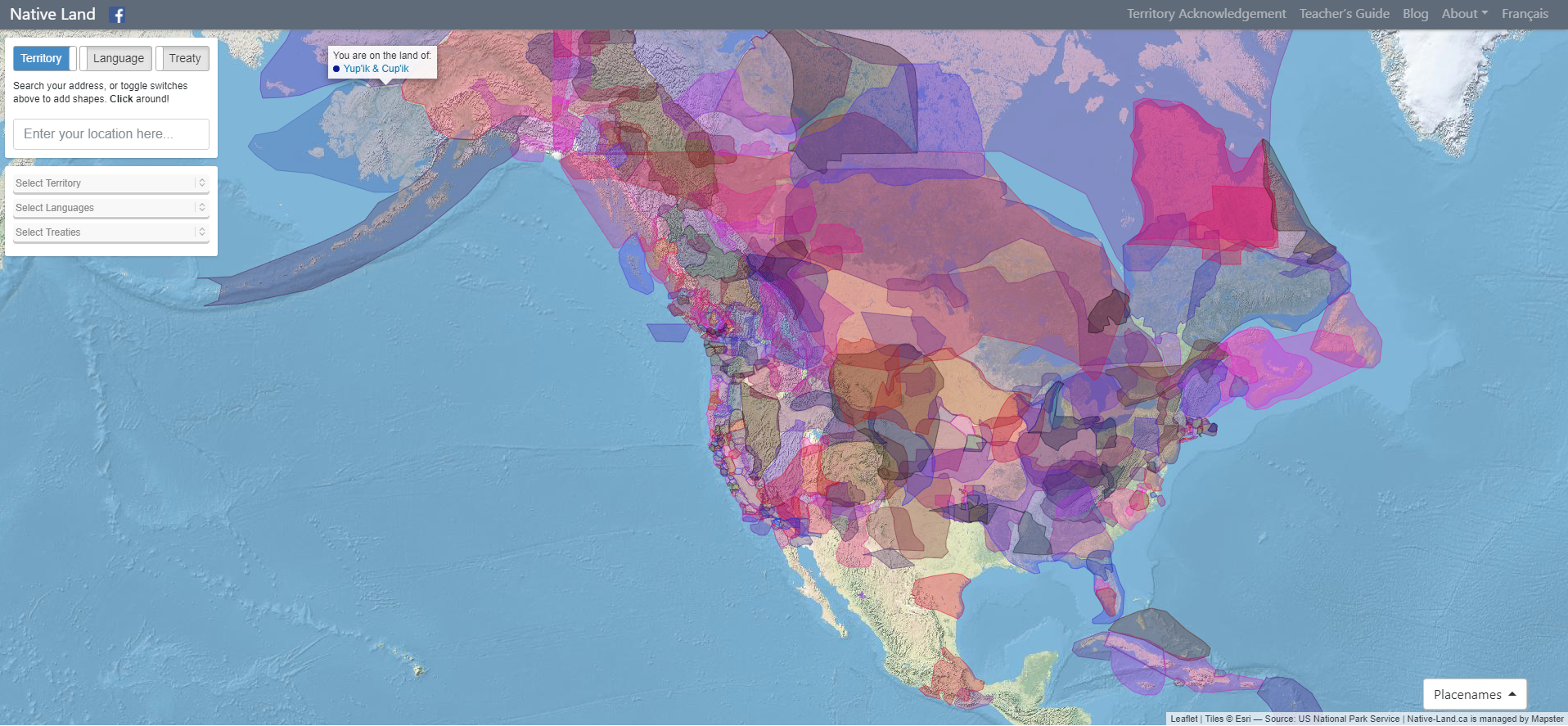
Native Land Digital strives to create and foster conversations about the history of colonialism, Indigenous ways of knowing, and settler-Indigenous relations, through educational resources such as our map and Territory Acknowledgement Guide. We strive to go beyond old ways of talking about Indigenous people and to develop a platform where Indigenous communities can represent themselves and their histories on their own terms. In doing so, Native Land Digital creates spaces where non-Indigenous people can be invited and challenged to learn more about the lands they inhabit, the history of those lands, and how to actively be part of a better future going forward together.
The Importance of Land
Land is something sacred to all of us, whether we consciously appreciate it or not — it is the space upon which we play, live, eat, find love, and experience life. The land is ever-changing and ever-shifting, giving us — and other creatures and beings on the earth — an infinite number of gifts and lessons.
For Native Land Digital, what we are mapping is more than just a flat picture. The land itself is sacred, and it is not easy to draw lines that divide it up into chunks that delineate who “owns” different parts of land. In reality, we know that the land is not something to be exploited and “owned”, but something to be honoured and treasured. However, because of the complexities of history, the kind of mapping we undetake is an important exercise, insofar as it brings an awareness of the real lived history of Indigenous peoples and nations in a long era of colonialism.
We aim to improve the relationship of people, Indigenous and non-Indigenous, with the land around them and with the real history and sacredness of that land. This involves acknowledging and righting the wrongs of history, and also involves a personal journey through the importance of connecting with the earth, its creatures, and its teachings.
Thus, while we make a strong effort to teach about colonialism and to bring forth Indigenous narratives, we also strive to integrate what is sometimes called an “Indigenous way of knowing” when it comes to the importance and sacredness of land in our daily lives. We hope to inspire people to gain a better understanding of themselves, their ancestors, and the world they live in, so that we can all move forward into a better future.
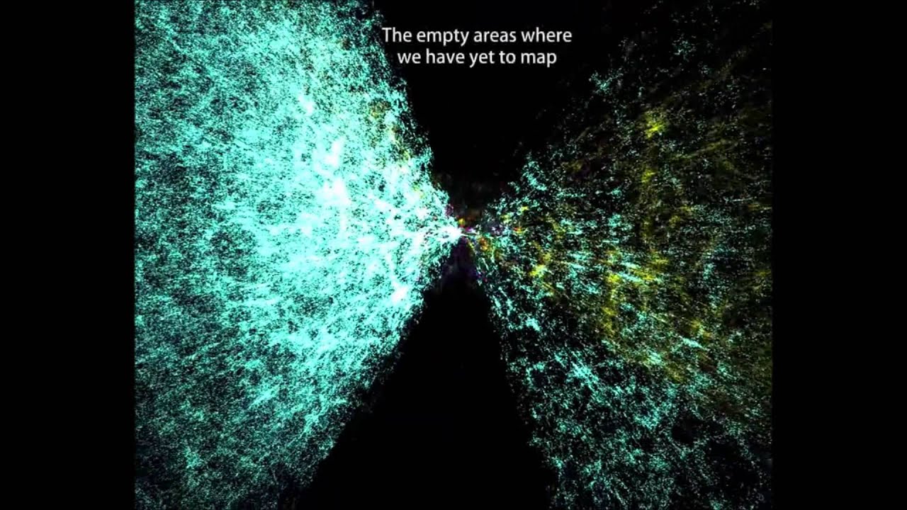
The Known Universe takes viewers from the Himalayas through our atmosphere and the inky black of space to the afterglow of the Big Bang. Every star, planet, and quasar seen in the film is possible because of the world's most complete four-dimensional map of the universe, the Digital Universe Atlas that is maintained and updated by astrophysicists at the American Museum of Natural History. The new film, created by the Museum, is part of an exhibition, Visions of the Cosmos: From the Milky Ocean to an Evolving Universe, at the Rubin Museum of Art in Manhattan through May 2010.
Data: Digital Universe, American Museum of Natural History
Visualization Software: Uniview by SCISS

It took 200,000 years for our human population to reach 1 billion—and only 200 years to reach 7 billion. But growth has begun slowing, as women have fewer babies on average. When will our global population peak? And how can we minimize our impact on Earth’s resources, even as we approach 11 billion?
Satire and cartography rarely come in a single package but in the Atlas of Prejudice they successfully blend to produce a book that is shockingly funny and disturbingly thought-provoking all at the same time.

To see a total solar eclipse, you have to be in exactly the right place at exactly the right time—inside the moon’s dark inner shadow as the earth, moon, and sun align.
This map shows the paths of totality of upcoming total eclipses.
All news is local news. Local perspectives on global news. In your language.
We have indexed all newspapers and plotted their correct locations, in 39 countries. Might have missed some. And most newspapers in another 199 countries, a bunch of them not in their correct locations.
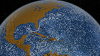
This visualization shows ocean surface currents around the world during the period from June 2005 through Decmeber 2007. The visualization does not include a narration or annotations; the goal was to use ocean flow data to create a simple, visceral experience.
WeatherSpark is a new type of weather website, with interactive weather graphs that allow you to pan and zoom through the entire history of any weather station on earth.
The Metro Wine Map of France, which re-draws the country’s wine appellations as stops on a regional subway line.
Home of the Internet's most complete country profiles. This site contains detailed country statistics, charts, and maps compiled from multiple sources.
The Atlas of True Names reveals the etymological roots, or original meanings, of the familiar terms on today's maps of the World, Europe, the British Isles and the United States.