https://www.atlasofplaces.com/research/infrastructure-patterns-i/
https://www.atlasofplaces.com/research/infrastructure-patterns-vii/

Atlas of Places is a public educational collection of Academia, Architecture, Cartography, Cinema, Essays, Painting, Photography and Research. Its objective is to question the meaning of places. It is curated according to continuously evolving philosophical, social and cultural beliefs. This is merely an occasional collection. Some works date from 1230, some from the recent past, some from the present. They have this characteristic in common that they are outlooks, in the truest sense of the word. In them will be found little more than the intention of clarifying a few ideas that might really be called political if that fine word, so attractive and exciting to the mind, did not arouse today so many great scruples and great repugnance.
Atlas of Places simply wishes to make a little clearer to itself the notions that it has received from others or that, like others, it has formed for itself — notions that everyone uses for thinking about human groups, their relations and difficulties with one another. The effort to clarify such matters is assuredly not the business of those men who practice or mix in them. This collection is the work of an amateur.
Atlas of Places is dedicated to those persons who have no system and belong to no party and are therefore still free to doubt whatever is doubtful and to maintain what is not.
Atlas of Places is curated day by day, the works shared do not pretend to show any organic development: the link between them is rather one of insistence and repetition. For while one doesn’t know whether things which are repeated are pleasing, one’s belief is that they are significant. And what is sought throughout this collection are significant features.
Atlas of Places produces cartography, satellite imagery and orthoimagery for exhibitions, editorial projects and various other mediums. This continuous production appears in the Research collection. If you wish to collaborate, please scroll down to the “Collaboration” section below.
Atlas of Places originated in the Pyrénées-Orientales during the summer of 2015 and is edited by Thomas Paturet.
Extreme Mercator projection with Marseille (France) as reference point (on the right side).
The map you see is the Mercator projection.
But unlike a standard Mercator projection, you can substitute any point on earth as the "pole". (The initial view shows Boston as the pole point)
Furthermore, this map cuts off much, much closer to the poles than normal, allowing you to see many more orders of magnitude of distortion.
Because this yields a map several times taller than it is wide, it is shown sideways from its usual orientation.
Backstory
The Mercator projection is infamous for its distortion at high latitudes. This distortion gets exponentially worse as you approach the poles. It is in fact impossible to show the poles on a Mercator map — they are infinitely far away.
Any Mercator map you've ever seen must cut off the top/bottom edges at some arbitrary point. The map usually stops hundreds, if not thousands of miles short of the poles.
But I've often wondered what lies beyond those cut-offs... to make a map that didn't cut off but simply kept going. As the distortion progresses towards infinity, you would eventually reach the scale of cities, houses, insects, atoms...
But of course that'd all be on a featureless expanse of ice.
To make things actually interesting, we must artifically shift the pole of the projection to a more interesting place. Imagine the earth encased by a rigid cage of latitude and longitude lines. We rotate the earth while leaving the cage fixed until a new point of interest has taken the place of the North Pole.
This is called an oblique Mercator, and is normally used to shift an area of interest onto the equator of the map to avoid distortion. But whereas others avoid the distortion, we embrace it.
Note how strange the oblique Mercator looks even without the increased cutoffs. The standard Mercator is so ingrained in the public consciousness that we perceive it as 'normal'. But once you shift the pole its pervasive distortion is shockingly apparent.
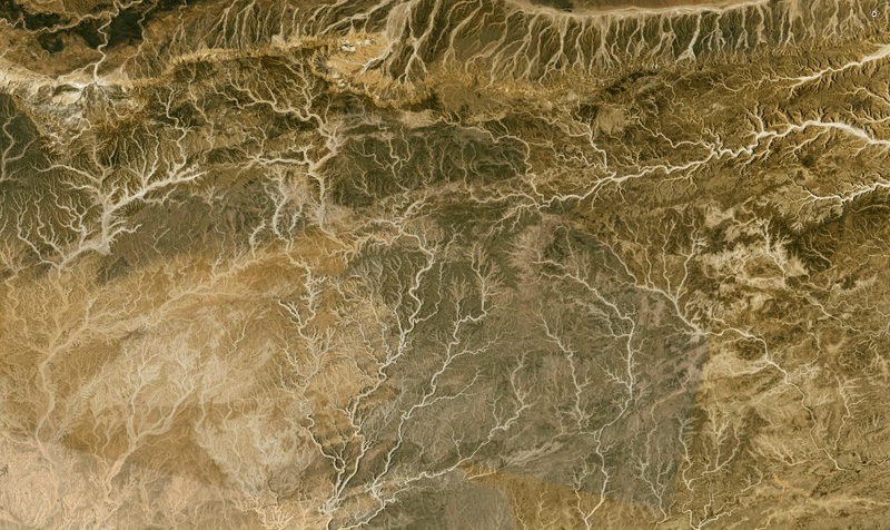
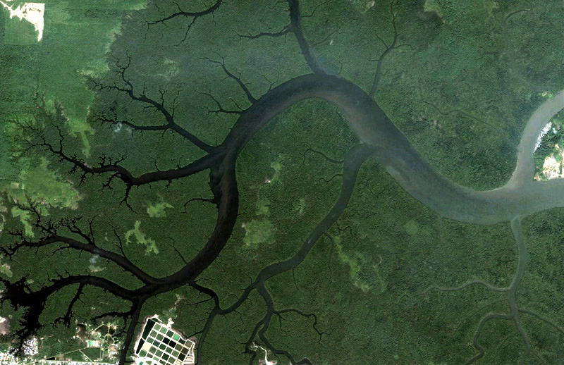
The following is a "photographic" gallery of fractal patterns found while exploring the planet with Google Earth. Each is provided with a KMZ file so the reader can explore the region for themselves. Readers are encouraged to submit their own discoveries for inclusion, credits will be included. Besides being examples of self similar fractals, they are often very beautiful structures ... not an uncommon characteristic of fractal geometry.
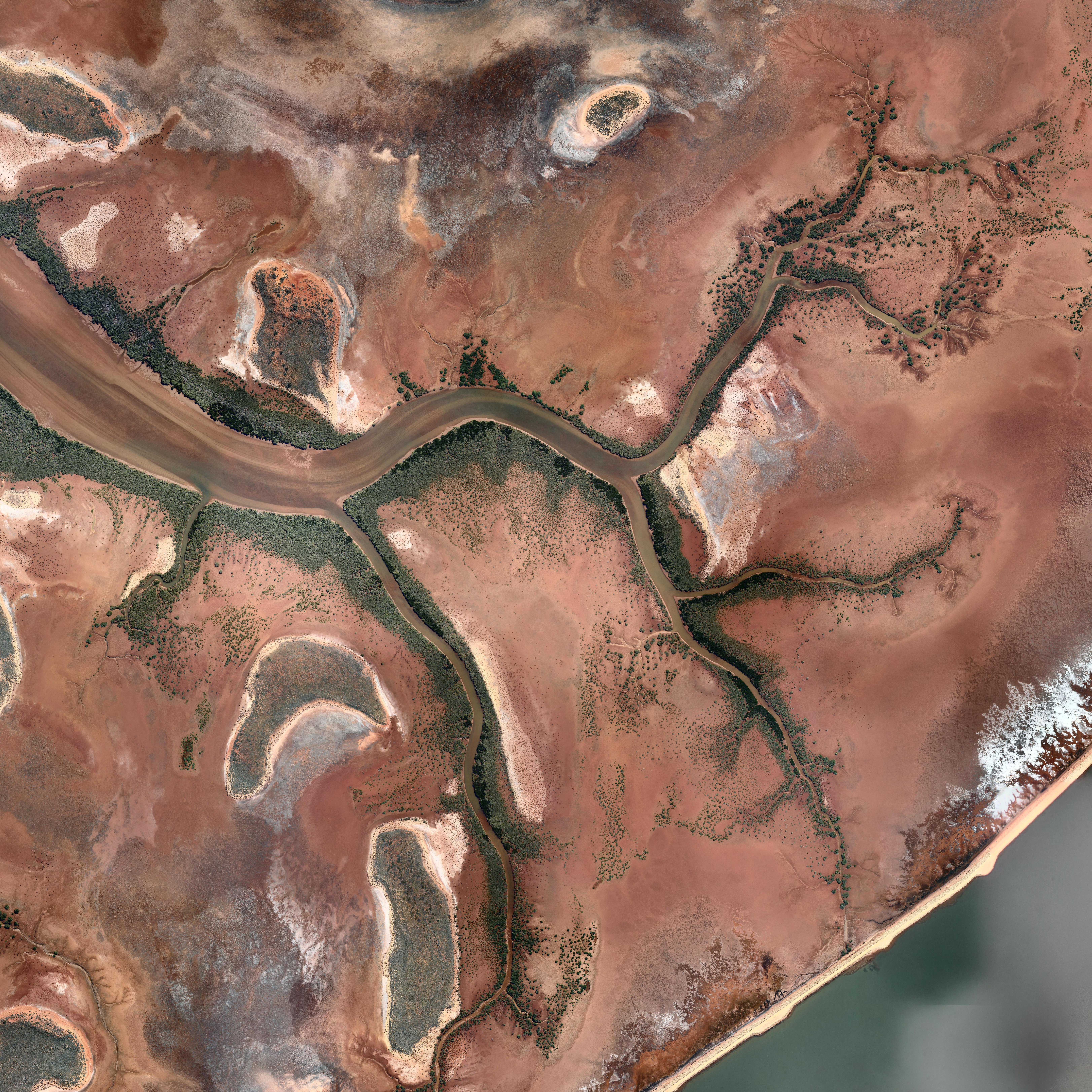
Self Similarity
Fractals are usually associated with self similarity across scales. For pure/idealised mathematical fractals the self similarity may be across an infinite range of scales, such as the Sierpinski Gasket. In real life and in nature the self similarity is only across a range of scales. Branching structures, such as most of the examples shown here, are classic examples of self similarity across 2, 3 or 4 scales. As with many plants, a thick branch (trunk) branches into one or more smaller branches, which in turn split into one or more smaller branches, and so on. The structure is similar at each scale, from the twigs to the main tree trunk.
An example of this for a river system is illustrated below, clicking on an image will give the high resolution version of the image without the markings. For the image on the right the pixel size is 30cm, the image on the right has a pixel size of 7.5cm. At each scale the branching structures are similar in appearance.

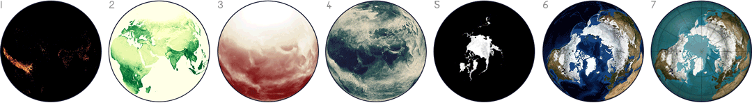
NASA publishes many Earth datasets at monthly time scales, and this GIF uses one frame per month to show the fluctuating seasons. The animation focuses mainly on data about Arctic sea ice and vegetation, but it was hard to choose - NASA has many other beautiful seasonal datasets, like fire, temperature, or rainfall.

The Electricity Map is developed and maintained by Tomorrow, a small Danish/French start-up company. Our goal is to help humanity reach a sustainable state of existence by quantifying, and making widely accessible, the climate impact of the daily choices we make.
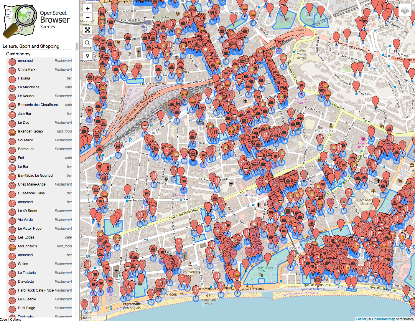
The OpenStreetBrowser is an application to 'browse' through the information in the displayed part of the map. The aim of the project is to provide a highly dynamic map that makes every mapped feature easily available to the user.
![]()
Histomap: a visualization of 4000 years of History, created in 1931 by John B. Sparks.


All three maps continue reasonate with me. The first offers us a stategic overlay. Which countries are powers/maintainers of the international system – which places are seeking to radical alter it, or cannot seem to become part of the core.
The second shows the virtual implications of that gap. Here, the gap between core and periphery is made starkly clear in technology use.
The final shows the physical manifestation of the gap. A stark reminder of the fences we build and the enormous sums of money and energy poured into keeping certain people out.
As a final note, I do think the third map is slightly misleading. As disturbing as it is, it is actually far, far too flattering to many traditional western powers as it continues to place them at the “centre.” In a world where the United States appears to be in decline this type of map makes China, Brazil, India and Russia (and even South Africa) look like non entities. Nothing could be further from the truth.
The project, named Open Antarctica, would aim to initially document a region of roughly 2 miles surrounding the Palmer Station United States base on the Antarctic Peninsula.
Our first question was: wait, there's Internet in Antarctica? And yes, there is Internet access on the Antarctic bases — access that's provided over an awesome looking, though incredibly slow, satellite uplink. So slow, in fact, that we briefly thought about sending our contact down to Antarctica with a plug-in computer running a little LocalWiki server — but ultimately decided it was too much work for little gain.
The next thing we started thinking about was mapping. Maps are a core feature of LocalWiki, so having a good map of the area, particularly the area near the research station, was really important. And ideally we'd have some aerial imagery and not just a vector map. "Let's take a look at some maps of the area!" we thought.
United Arab Emirates billionaire Sheikh Hamad Bin Hamdan Al Nahyan has etched his name in the sand on Al Futaysi island in Abu Dhabi in such big letters it can be seen from space.
A satellite image from space confirms the enormous letters of the name “HAMAD” carved into the sand on Al Futaisi Island in Abu Dhabi. The name stretches a staggering two miles long and will likely be a permanent fixture on the distant island.
The island of Futaisi lies near the barrier island of Bahrani, in a shallow sheltered lagoon-type complex to the southwest of Abu Dhabi Island.
Billionaire Sheikh Carves Name Hamad in Sand; Visible From Space
The Peters Projection World Map is one of the most stimulating, and controversial, images of the world. This map was first introduced by historian and cartographer Dr. Arno Peters at a Press Conference in Germany in 1974.

All online newspapers in the world, translate with one click
HyperCities makes possible for geographic maps to seamlessly merging the historical representations of the city in their current situation, and thus connecting the digital archives, maps, and stories with the physical world.
This map is an illustration in ‘The Hunting of the Snark (An Agony in 8 Fits)’, a nonsensical and somewhat grim poem by Lewis Carroll
What would the Earth look like if every elevation was inverted? If oceans were mountains and vice versa? Bathymetric (ocean depth) information from NASA is recolored here using topographic information.
Spectacular satellite images of the world
The Atlas of True Names reveals the etymological roots, or original meanings, of the familiar terms on today's maps of the World, Europe, the British Isles and the United States.
More than any time in the history of the Web, incumbents in the network economy are consolidating their power and staking new claims to key points of control. Welcome to the first iteration of the Web 2.0 Summit's theme, Points of Control!
The Hand Drawn Map Association (HDMA) is an ongoing archive of user submitted maps and other interesting diagrams created by hand.
Hideous monsters devouring ships? Cryptic symbols, correctly showing storm fronts & dangerous currents
See european cities as a bird.
A collection of awesome Google-related projects from people around the world
Map of stars, mars and the moon
Show your favourite places. Mashup of Google map and photos.
Google Map with a topographic layer of France from 18th century
remix your city
Sonic map of the Island of Capri
The Danube Panorama Project is an experimental approach to photographic mapping and cartography. It's goal is to produce a full panorama of the Danube's river sides by digitally slit-scanning its coastlines, resulting in a unique 'cross section' of co
Abstraction today is no longer that of the map, the double, the mirror or the concept. Simulation is no longer that of a territory, a referential being or substance. It is the generation of models of a real without origin or reality: a hyperreal.
Forbidden places
Google maps in ascii characters
The google maps flight sim
Wiki + googlemaps
Googlemap webcam
Point of view exctract from google earth
Vector overlays for google maps
Collections of notorious places
Ideas and tools being influenced by google maps